

Master the wilderness with confidence through hands-on backcountry navigation training in Ontario’s rugged terrain. Learn to read topographical maps, use a compass with precision, and navigate challenging landscapes while developing essential survival skills that could save your life. Whether you’re planning a remote canoe trip in Algonquin or a challenging hike through the Canadian Shield, proper navigation techniques are your lifeline in the wilderness.
Our comprehensive course transforms novice outdoors enthusiasts into confident navigators through practical, real-world scenarios. You’ll practice route-finding in varying conditions, master GPS technology while understanding its limitations, and learn time-tested techniques that don’t rely on battery power. Beyond basic orienteering, you’ll discover how to read natural indicators like moss patterns, star positions, and weather systems to maintain your bearings in Ontario’s diverse backcountry landscapes.
Join experienced wilderness guides who share their hard-won knowledge through engaging, hands-on instruction that prioritizes safety while building your confidence step by step. This isn’t just about following trails – it’s about developing the skills to forge your own path safely through the wild.

Essential Navigation Tools for Ontario’s Backcountry
Maps and Map Reading Fundamentals
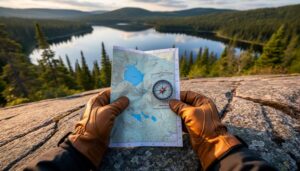
In Ontario Parks, you’ll primarily work with two types of maps: topographic maps from Natural Resources Canada and official park maps. These maps are like your wilderness blueprint, showing everything from elevation changes to campsites and portage routes. Think of topo maps as your detailed terrain guide, with those squiggly contour lines telling the story of every hill and valley you’ll encounter.
Park-specific maps are your best friends for navigation in Ontario’s backcountry, highlighting trails, water sources, and designated camping areas. They’re designed with hikers and campers in mind, making them perfect companions to your essential safety gear.
Pro tip: Always look for the map’s scale and legend first – they’re like the decoder ring for your wilderness puzzle! Learn to identify key symbols for features like marshes, cliffs, and trail intersections. In Ontario’s diverse landscape, you’ll frequently encounter water features, so pay special attention to shoreline details and portage markers.
Remember to keep your map in a waterproof case – our humid summers and unexpected rain showers can quickly turn your navigation tool into papier-mâché!
Compass Basics and Selection
When navigating Ontario’s diverse landscapes, from the Canadian Shield to dense forests, having the right compass is essential. Look for a baseplate compass with adjustable declination – this feature is crucial as magnetic north varies across the province. I recommend models from trusted brands like Silva or Suunto, which typically range from $30-60.
Your compass should have clear degree markings, a rotating bezel, and a transparent base for easy map reading. A sighting mirror can be helpful but isn’t necessary for beginners. The liquid-filled housing should be bubble-free, as bubbles can affect accuracy, especially in our varying temperatures.
Pro tip: Before heading out, test your compass away from metal objects and electronic devices. Many trails in Ontario have high iron content in the rocks, which can affect readings. Keep your compass in a separate pocket away from your phone or other electronics.
Remember to handle your compass with care – dropping it can damage the magnetic needle. Consider getting a lanyard to keep it secure during those scrambles over Canadian Shield rocks or through thick brush.
Navigation Techniques You’ll Master
Taking Bearings in Dense Forest
Navigating through Ontario’s dense forests presents unique challenges that require specific wilderness navigation strategies. When the canopy blocks your view of distant landmarks, you’ll need to rely on careful compass work and close-range navigation techniques.
Start by identifying small-scale features like distinctive trees, rock formations, or small clearings that can serve as intermediate waypoints. In thick woodland, it’s best to take multiple bearings from different positions to triangulate your location accurately. I’ve found that marking your path with biodegradable trail tape can be helpful, especially when backtracking is necessary.
One local trick I’ve learned while teaching in Algonquin Park is to use the predominant wind direction, which has shaped many of our older trees. These trees often lean slightly southeast, providing a natural compass when other references aren’t visible.
Remember to check your bearing more frequently in dense forest than you would in open terrain – aim for every 50 to 100 meters. This helps prevent drift from your intended course. Keep your compass at chest height and away from any metal objects, including your hiking poles or camera equipment.
When possible, use natural handrails like streams, ridgelines, or old logging roads as navigation aids. These features are particularly valuable in Ontario’s boreal forest, where visibility can be limited to just a few meters during peak growing season.

Trail and Terrain Features
Ontario’s backcountry trails offer a rich variety of natural landmarks and trail markers that, once understood, become your reliable navigation allies. In provincial parks like Algonquin and Killarney, you’ll learn to identify distinctive features such as rock formations, stream crossings, and unique tree patterns that serve as natural waypoints.
During your navigation course, you’ll discover how to read and interpret the standardized trail blazes – those reassuring painted markers on trees that keep you on track. Blue blazes typically indicate side trails, while white blazes mark main routes. You’ll also become familiar with cairns (stacked rock formations) that guide hikers across bare rock surfaces, particularly common in the Canadian Shield regions.
Ontario’s terrain offers perfect training grounds for recognizing landforms. You’ll practice identifying subtle changes in elevation, detecting ridgelines, and understanding how valleys and water features can orient you in the wilderness. The course pays special attention to reading shorelines and understanding how Ontario’s numerous lakes and rivers can serve as both navigational aids and potential barriers.
Insider tip: Keep an eye out for beaver dams and distinct tree stands – these natural features often mark significant trail intersections or camping areas in Ontario’s parks. Learning to spot these indicators can make the difference between staying on course and taking an unplanned detour in the backcountry.
Night Navigation Skills
When the sun sets, the backcountry transforms into a different world, and navigation takes on new challenges. That’s why we dedicate a full evening to mastering night navigation techniques – skills that could prove invaluable during unexpected delays or emergencies.
During this portion of the course, you’ll learn how to use your headlamp effectively without compromising your night vision. We’ll practice the technique of using a red light filter, which helps preserve your natural night vision while still allowing you to read maps and compasses.
One of our favorite exercises involves identifying natural nighttime navigational aids, like the North Star (Polaris), and learning how to use major constellations as reliable direction indicators. We’ll show you how to measure distances at night using pace counting and timing methods, essential skills when visibility is limited.
You’ll also master the art of using terrain features as handrails in the dark – following streams, ridgelines, or forest edges to maintain your bearing. We’ll practice emergency navigation scenarios and teach you how to safely hunker down if conditions become too challenging.
Pro tip: Bring a backup headlamp and extra batteries! There’s nothing worse than having your light source die in the middle of a night navigation exercise. Remember, confidence in night navigation isn’t just about having the right tools – it’s about practice and preparation.

Real-World Practice Locations
Beginner-Friendly Training Areas
For those just starting their navigation journey, Ontario offers several perfect training grounds where you can practice your newfound skills safely. The Arrowhead Provincial Park, just north of Huntsville, features well-marked trails and distinct landmarks, making it an ideal spot for beginners to practice map reading and compass work without venturing too far from civilization.
Bronte Creek Provincial Park, near the GTA, provides another excellent training area with its mix of open meadows and wooded areas. The park’s gentle terrain and clear boundaries allow novice navigators to build confidence while having obvious reference points to stay oriented.
A local favorite for navigation practice is Mono Cliffs Provincial Park, where the distinct escarpment features serve as natural navigation aids. The park’s network of intersecting trails offers varying difficulty levels, perfect for progressively challenging yourself as your skills improve.
Insider tip: Start your practice sessions in these parks during spring or fall when the crowds are thinner and the weather is mild. The shorter days will also give you a chance to practice twilight navigation in a controlled environment.
Remember to always sign in at the trail registers and inform someone of your training plans, even in these beginner-friendly areas. It’s good practice for when you venture into more challenging terrain later on.
Advanced Navigation Challenges
Ready to put your basic navigation skills to the test? Our advanced challenges take you through some of Ontario’s most intricate terrains, where you’ll face real-world scenarios that will sharpen your navigation prowess.
In this section, you’ll tackle dense forest routes where trail markers are sparse, navigate through wetland complexes, and plot courses through areas with significant elevation changes. We’ll introduce you to night navigation exercises using celestial bodies and practice emergency orientation techniques when visibility is poor.
Working in small groups, you’ll complete a series of mini-expeditions that combine multiple navigation techniques. Picture yourself finding your way through the Canadian Shield’s rocky outcrops, using both natural landmarks and precise compass bearings to stay on course. You’ll learn to navigate confidently through areas where GPS signals might be unreliable, ensuring you always have a backup plan.
Our instructor’s favorite challenge? The “lost and found” exercise, where you’ll deliberately venture off course in a controlled environment and use your newfound skills to reorient yourself. It’s an eye-opening experience that builds confidence and teaches valuable problem-solving skills.
We’ve carefully designed these challenges to simulate real backcountry situations while maintaining a safe learning environment. Each exercise builds upon the previous one, helping you develop the judgment and decision-making skills essential for wilderness navigation.
Pro tip: Bring a waterproof notebook to jot down your observations and lessons learned during these exercises – it’ll become an invaluable reference for your future adventures.
Safety Protocols and Emergency Planning
Navigation Backup Systems
While digital tools like GPS devices and smartphone apps are invaluable for modern navigation, every seasoned backcountry explorer knows the importance of reliable backup systems. As part of our comprehensive wilderness safety skills, we’ll teach you multiple navigation methods to ensure you’re never truly lost.
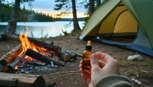
Your navigation kit should include a high-quality compass (we recommend the Silva Ranger series), detailed topographic maps in a waterproof case, and an emergency whistle. We’ll show you how to waterproof your maps using simple household materials – a trick I learned after an unexpected downpour nearly ruined my only map during a Killarney trek!
Pro tip: Always carry a small signal mirror and a backup button compass on your jacket zipper. These lightweight tools can be lifesavers when primary navigation methods fail. We’ll practice using these tools in various weather conditions and terrains typical to Ontario’s backcountry.
During the course, you’ll learn to navigate using natural indicators like the sun’s position, tree moss patterns, and star formations – traditional techniques that have guided explorers for centuries. We’ll also cover how to mark trails using biodegradable materials and create emergency signals that can be spotted from the air.
Remember, the best backup system is the one you know how to use effectively. That’s why we dedicate significant hands-on practice time to these essential skills.
When Things Go Wrong
Even with the best preparation, unexpected situations can arise in the backcountry. That’s why knowing how to handle emergencies is just as crucial as mastering navigation skills. Always carry a fully charged cell phone, but remember that coverage can be spotty in remote areas. Before heading out, download offline maps and share your planned route with someone you trust.
If you become lost, remember the STOP principle: Stop, Think, Observe, and Plan. Stay calm and follow the emergency protocols you learned during the course. Your emergency kit should include a whistle (three blasts is the universal distress signal), an emergency shelter, and a satellite communication device if possible.
For immediate assistance in Ontario’s backcountry, contact the park office at the number provided during registration. In life-threatening emergencies, activate your satellite device or call 911 if you have cell service. The Ontario Provincial Police coordinates search and rescue operations in most wilderness areas.
Pro tip: Take a photo of the trail map at the trailhead with your phone – it serves as a backup even if your paper map gets damaged. Also, marking your parking spot’s coordinates before starting your hike can be a literal lifesaver if you need to guide emergency services to your location.
Mastering backcountry navigation is an incredible journey that opens up a world of wilderness adventures. Through this course, you’ll gain the confidence to explore Ontario’s stunning backcountry while staying safe and oriented. Remember, the key to successful navigation isn’t just about memorizing techniques – it’s about practicing these skills regularly and building your confidence gradually.
Start with simple day hikes to practice your map and compass skills before venturing into more challenging terrain. Keep a navigation log of your experiences, noting what worked well and areas where you need more practice. Don’t be afraid to make mistakes during your learning process – that’s often where the best lessons come from!
Whether you’re planning a weekend camping trip in Algonquin Park or dreaming of a longer expedition in the wilderness, the skills you’ll learn in this course will serve you well. Navigation isn’t just about reaching your destination; it’s about enjoying the journey safely and responsibly while minimizing your impact on our precious natural spaces.
We encourage you to take that first step today. Sign up for a course, gather your basic navigation tools, and start exploring Ontario’s magnificent backcountry. The wilderness is calling, and with these essential navigation skills, you’ll be ready to answer that call with confidence and competence.
Remember, every expert navigator started as a beginner. Your adventure in backcountry navigation begins now!


+ There are no comments
Add yours