

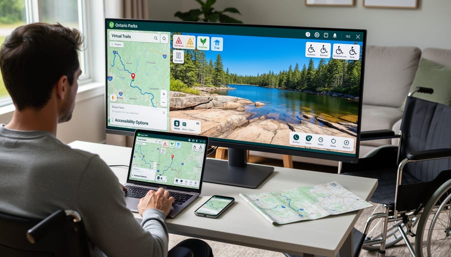
Explore Ontario’s stunning provincial parks without leaving your couch by downloading the official Ontario Parks app, which offers interactive trail maps, real-time campsite availability, and virtual tours of popular destinations like Algonquin and Killarney. Navigate to Google Earth and search for specific park names to experience breathtaking aerial flyovers of rugged Canadian Shield landscapes, pristine lakes, and dense forests that’ll help you identify the perfect hiking routes before you arrive. Access free 360-degree virtual tours on many park websites where you can preview campsites, beach areas, and visitor centers, making it easier to plan accessible trips or scout locations for families with young children.
Virtual park tools have transformed how we experience Ontario’s natural treasures, whether you’re homebound, planning your next adventure, or simply craving a midday nature escape during work breaks. These digital experiences serve everyone from seniors with mobility challenges who want to revisit beloved trails to newcomers researching their first camping trip. You’ll discover hidden waterfalls, identify bird-watching hotspots, and even check current trail conditions through webcams positioned at key viewpoints. The best part? These virtual explorations are completely free and available year-round, letting you scout snowy winter landscapes in July or preview fall colors while planning your September getaway. This digital approach also supports eco-friendly trip planning by helping you make informed decisions before arrival, reducing unnecessary driving and minimizing your environmental footprint.
What is Virtual Park Exploration?
Who Benefits Most from Virtual Park Tours
Virtual park tours open doors for so many people who might otherwise miss out on Ontario’s natural beauty. For folks with mobility challenges, these digital experiences eliminate physical barriers—you can explore rugged backcountry trails from the comfort of home without worrying about uneven terrain or accessibility limitations.
Families planning their next camping adventure absolutely love these tools. You can scout out campsites, check trail difficulty levels, and even show the kids what to expect before packing the car. It takes the guesswork out of trip planning and helps avoid those “are we there yet?” disappointments.
Teachers and students benefit enormously too. Virtual tours bring geography and ecology lessons to life, allowing classrooms across the province to study provincial parks without leaving school grounds. It’s hands-on learning without the field trip logistics.
Snowbirds spending winters down south can stay connected to their favourite Ontario haunts through virtual visits—a wonderful way to satisfy those nature cravings when you’re missing home. International visitors researching Canadian destinations find these tours invaluable for deciding which parks to visit during their trip.
This technology transforming tourism truly makes nature more accessible to everyone.
Ontario’s Best Virtual Park Exploration Tools
360-Degree Virtual Tours
Ready to explore Ontario’s natural wonders without leaving your couch? Several provincial parks now offer stunning 360-degree virtual tours that transport you directly into these incredible landscapes. Think of it as your personal preview before planning that weekend getaway, or a way to revisit your favorite trails during those long winter months.
Algonquin Provincial Park leads the pack with breathtaking panoramic views of popular spots like the Lookout Trail and Centennial Ridges. You can virtually stand at scenic overlooks, pan around to take in the forest canopy, and even zoom in on details you might miss during an actual hike. The interface is wonderfully intuitive—just click and drag to look around, or use arrow keys to move between viewpoints.
Killarney Provincial Park offers equally impressive virtual experiences, showcasing those iconic white quartzite ridges against brilliant blue waters. The George Lake area tour lets you explore the shoreline and imagine yourself paddling those crystal-clear waters. Meanwhile, Bon Echo Provincial Park’s virtual tour brings you face-to-face with the massive Mazinaw Rock and its ancient Indigenous pictographs.
Navigation is straightforward on most platforms. Look for hotspot markers that transport you to different locations within the park, and don’t forget to toggle the full-screen mode for maximum immersion.
Here’s an insider tip: visit these virtual tours during actual sunrise or sunset hours. Something magical happens when you’re virtually exploring a trail bathed in golden hour light while sipping your morning coffee—it’s the next best thing to being there, and the perfect inspiration for planning your next adventure.
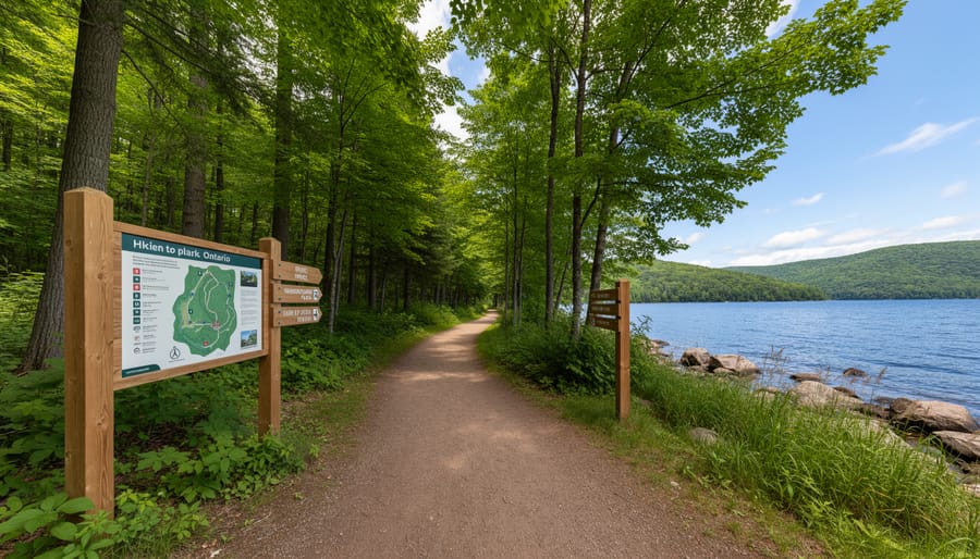
Interactive Park Maps and Trail Previews
Planning your Ontario park adventure just got a whole lot easier with digital mapping tools that bring trails, campsites, and facilities right to your screen. These interactive park maps let you virtually explore every corner of a park before you even pack your backpack, helping you make informed decisions about where to spend your precious outdoor time.
Picture this: you’re eyeing a weekend camping trip but aren’t sure which site offers the best lake views or easiest access for your family. With virtual mapping tools, you can zoom into individual campsites, check their proximity to washrooms and water sources, and even preview trail difficulty ratings. Many Ontario parks now offer 360-degree views of popular routes, so you’ll know whether that “moderate” trail suits your fitness level.
Here’s an insider tip: use these digital maps to scout out quieter trails and hidden gems that casual visitors might miss. You can measure distances, identify elevation changes, and locate scenic lookout points worth the extra steps. For eco-conscious travelers, these tools help minimize your environmental impact by preventing wrong turns and unnecessary backtracking, keeping you on designated paths while protecting sensitive ecosystems.
Live Webcams and Seasonal Views
Want to see what’s happening at your favorite park right now? Live webcams offer a window into Ontario’s natural spaces, letting you check real-time conditions before you go or simply enjoy the view from your couch. Several provincial parks maintain these feeds, and they’re honestly addictive once you start watching.
Algonquin Provincial Park operates multiple webcams showcasing different locations, from the iconic Highway 60 corridor to lakeside vistas. I love checking them during fall colour season – you can literally watch the leaves change day by day and time your visit perfectly. Early morning is prime viewing time for wildlife sightings, especially around dawn when moose and deer are most active.
Insider tip: Bookmark webcams for parks you plan to visit and check them a day or two before your trip. You’ll see current weather conditions, water levels, and even parking lot situations during busy weekends. It’s saved me from showing up to overcrowded parks more than once.
Winter webcams are particularly magical. Watch snowfall accumulate, see ice formations develop, or catch cross-country skiers gliding past. Some feeds even capture the Northern Lights during clear winter nights in northern parks.
These cameras also serve an eco-friendly purpose – they help researchers monitor wildlife patterns and environmental changes without disturbing natural habitats. You might witness something extraordinary, like a bear ambling across a meadow or migrating birds stopping for rest.
Virtual Educational Programs and Guided Experiences
Beyond virtual tours, Ontario Parks offers a treasure trove of educational programming that transforms your living room into a classroom under the stars. I recently joined a virtual campfire talk led by a park naturalist from Algonquin, and honestly, my kids were more engaged than they’ve ever been on our actual camping trips – turns out, there’s something magical about seeing wildlife footage up close without the mosquitoes!
The online naturalist programs cover everything from bird identification workshops to stargazing sessions, complete with interactive Q&A portions where you can ask questions in real-time. My favorite insider tip? Check the Ontario Parks events calendar on weekday evenings when participation tends to be lower, giving you more one-on-one interaction with the naturalists.
Teachers absolutely love these resources for classroom integration. The educational content library includes downloadable activity sheets, seasonal nature journals, and pre-recorded presentations about topics like forest ecosystems and animal tracking. I’ve watched my niece’s third-grade class participate in a virtual guided hike through Bon Echo Provincial Park, with students shouting out observations as if they were actually on the trail.
The eco-friendly bonus here is significant – these programs reduce transportation emissions while making park experiences accessible to those with mobility challenges or limited travel budgets. Many programs are archived, so you can revisit your favorites anytime.
How to Use Virtual Tools for Better Trip Planning
Choosing Your Perfect Campsite Virtually
Picture this: you’re scrolling through campsite options at 11 PM, trying to figure out if Site 42 is too close to the bathrooms or if Site 67 offers enough tree cover for shade. Virtual park tools transform this guessing game into confident decision-making.
Start by accessing Ontario Parks’ interactive campground maps. Zoom in close enough to see individual site boundaries and notice details like tree placement and proximity to trails. I once avoided a potentially sleepless night by spotting that my initial choice sat right beside the park entrance—constant headlights would’ve been my midnight alarm clock!
Look for clues about privacy. Sites surrounded by dense vegetation icons typically offer more seclusion than those in open meadows. Check the distance between neighboring sites using the map’s measurement tools.
Assess your proximity to amenities strategically. Families with young children might prioritize being near washrooms, while tent campers often prefer distance from RV areas for a quieter experience.
Here’s an insider tip: enable satellite view if available. This reveals terrain features the standard map might miss—rocky patches, wet areas, or sunny versus shaded spots. Some parks even offer 360-degree virtual tours of popular sites.
Before clicking “book,” mentally walk through your typical camp day. Can you easily access water? Is the site level enough for comfortable sleeping? Virtual exploration answers these questions before you ever leave home.

Trail Research and Difficulty Assessment
Before I committed to a challenging 10-kilometer loop at Algonquin Park, I spent an evening exploring the trail virtually. Using the park’s 360-degree tour and topographic elevation maps, I discovered the route included a steep 200-meter climb in the final stretch—something the basic description hadn’t emphasized. Armed with this knowledge, I packed extra water and planned a slower pace. That preparation made all the difference.
Virtual tours paired with elevation profiles are game-changers for assessing trail difficulty honestly. Look beyond distance and check the cumulative elevation gain, which tells you how much uphill hiking you’ll actually face. Many Ontario parks now offer detailed digital maps showing gradient changes, rocky sections, and terrain types. The Parks Ontario website often links to these resources, and combining them with smart tech tools gives you a comprehensive picture.
Pro tip: Take virtual walk-throughs during different seasons if available. That sunny summer trail might look completely different with spring mud or fall leaves obscuring rocks. Check recent visitor photos on social media too—they often reveal current conditions that official tours don’t show. This homework prevents unpleasant surprises and helps you choose trails matching your actual fitness level, not your optimistic estimation of it.
Top Ontario Parks to Explore Virtually Right Now
Ready to explore Ontario’s natural wonders without leaving your couch? These parks offer some of the most impressive virtual experiences that’ll have you planning your next adventure—or simply enjoying a moment of digital nature therapy.
Algonquin Provincial Park stands out as the crown jewel of virtual exploration. Their 360-degree tours take you deep into the iconic autumn forests, where you can practically hear the leaves crunching underfoot. Look for the interactive canoe route previews—they’re absolutely invaluable for planning your paddling adventure. Insider tip: Check out their virtual wildlife camera feeds during dawn and dusk for the best chance of spotting moose and bears in real-time.
Bruce Peninsula National Park offers breathtaking cliff-side views through their immersive virtual tours. The Grotto viewpoint experience is particularly stunning, showcasing those famous turquoise waters against white limestone cliffs. What makes this tour special is the geological information overlay—you’ll learn why the water glows that incredible blue color. Don’t miss the underwater cave perspectives that most visitors never get to see in person.
Killarney Provincial Park’s virtual hiking trails provide a eco-friendly way to preview the stunning La Cloche Mountains before you visit. Their drone footage captures the pink granite ridges and crystal-clear lakes from angles impossible to appreciate from the ground. Watch for the virtual kayaking segments that show you exactly what to expect on Georgian Bay’s waters.
Point Pelee National Park delivers exceptional bird-watching opportunities through their seasonal migration webcams. Spring and fall are prime viewing times when thousands of birds pass through Canada’s southernmost point. The marsh boardwalk virtual tour is surprisingly peaceful—perfect for a midday mental break.
Awenda Provincial Park rounds out our list with family-friendly virtual beach tours and forest trail previews that help you choose the perfect spot for your next camping trip.
Making the Most of Your Virtual Park Experience
Want to get the absolute best from your virtual park adventures? Here’s the inside scoop: start with your largest screen possible. While smartphones work in a pinch, tablets or laptops really let you appreciate the stunning details of 360-degree views and interactive maps. I often cast virtual tours to my TV for a truly immersive family experience—it transforms our living room into a planning headquarters!
Combine multiple tools for richer exploration. Pull up Google Earth alongside official park maps, then switch to trail cameras for real-time wildlife spotting. My favorite trick? Screen-grab compelling views during virtual tours and compile them into a digital scrapboard. You can even try digital nature journaling to document your discoveries before ever leaving home.
Make it social! Share virtual tours with family members during video calls—grandparents especially love “visiting” parks with grandkids this way. Create a shared album where everyone saves their favorite virtual spots, then vote on which locations to visit first.
Here’s the eco-friendly bonus nobody talks about: virtual scouting drastically reduces unnecessary drive-by trips. Instead of burning fuel to check if a beach is sandy or rocky, you’ll know beforehand. One virtual tour can replace multiple reconnaissance visits, shrinking your carbon footprint while building anticipation. You’ll arrive at your chosen park confident, prepared, and ready to dive straight into adventure.
Here’s something I’ve learned from years of exploring Ontario’s wilderness: virtual tools aren’t meant to replace the feeling of pine-scented air on your face or the crunch of autumn leaves beneath your boots. Think of them as your planning companion, your accessibility bridge, or your way to relive cherished memories during those long winter evenings when the trails are buried in snow.
Whether you’re using virtual tours to scout your next camping spot, helping an elderly relative revisit their favourite lookout point, or simply daydreaming about summer adventures from your couch, these digital windows into Ontario’s natural spaces serve a beautiful purpose. They make our parks more accessible to everyone, regardless of physical ability or geographic distance.
My insider tip? Start with a virtual exploration of a park you’ve never visited. Let the 360-degree views and interactive maps spark your curiosity. Make notes of trails that catch your eye, then plan your real-world adventure. You’ll arrive better prepared and more excited than ever.
Ontario’s natural beauty deserves to be experienced with all your senses, but there’s no harm in getting a digital preview first. So go ahead—fire up that virtual tour tonight, and start planning which park you’ll explore in person next. Your next adventure is just a click away.


+ There are no comments
Add yours