
Deep in Ontario’s provincial parks and wilderness areas, GPS wildlife tracking has revolutionized how we understand and protect our most endangered species. From tiny songbirds wearing ultra-lightweight transmitters to massive moose equipped with solar-powered collars, these remarkable devices are unveiling the secret lives of animals with unprecedented precision. Today’s AI-powered tracking systems don’t just plot points on a map – they reveal complex migration patterns, identify critical habitats, and alert conservationists to potential threats in real-time. Gone are the days of relying solely on physical observations and manual tracking methods. Modern wildlife biologists can now monitor entire populations from their smartphones, collecting millions of data points that paint a detailed picture of animal behavior, survival strategies, and habitat preferences. This technology has become an indispensable tool in our mission to protect wildlife, allowing us to make informed decisions about conservation efforts and ensure the survival of countless species for generations to come.
The Evolution of Wildlife Tracking in Ontario Parks
From Radio Collars to Smart Sensors
Wildlife tracking has come a long way since the early days of simple radio collars. Back in the 1960s, researchers would spend countless hours trudging through forests with handheld antennas, hoping to pick up signals from tagged animals. It was exhausting work, but it laid the foundation for what would become modern conservation methods.
The game-changer arrived in the 1990s with GPS technology. Suddenly, researchers could monitor animals’ movements with incredible precision, right from their computers. Here in Ontario, we’ve seen this evolution firsthand, from tracking individual moose and wolves to understanding entire ecosystem patterns.
Today’s smart sensors are like tiny computers, collecting data not just about location, but also about an animal’s behavior, health, and environment. They’re smaller, lighter, and more powerful than ever before. Some can even send real-time alerts when an animal enters a specific area or shows unusual behavior patterns.
The best part? These advances have made wildlife monitoring more accessible and less invasive for the animals. It’s amazing to think how far we’ve come from those early radio tracking days!
Current GPS Technology in Our Parks
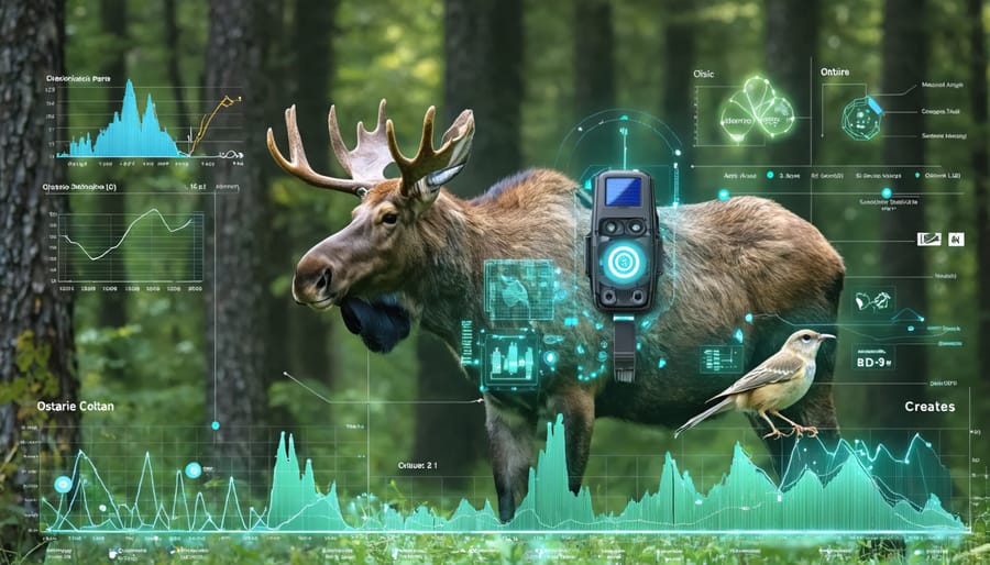
Today’s GPS tracking systems in Ontario’s parks are more sophisticated than ever, combining miniaturized technology with incredible accuracy. Modern tracking devices can be as small as a coin, making them perfect for monitoring even our smallest wildlife residents without disruption to their natural behaviors.
These smart devices do more than just track location – they collect valuable data about animal movement patterns, feeding habits, and even body temperature. Many of our tracked animals wear special collars equipped with solar panels, extending battery life for years of continuous monitoring.
What’s really exciting is how this technology connects to our visitor experience. Through our mobile app, park visitors can sometimes see recent wildlife movement data, helping them understand where certain species tend to gather. For example, at Algonquin Park, researchers use GPS tracking to monitor wolf pack movements, giving visitors better chances of hearing their haunting howls during evening programs.
Our park naturalists also use this data to enhance guided walks, sharing real-time insights about local wildlife movements and helping visitors understand the fascinating patterns of animal behavior in our parks.
How AI is Revolutionizing Wildlife Monitoring
Smart Pattern Recognition
Ever wondered how researchers can tell if a moose is sleeping or grazing just by looking at GPS data points? That’s where smart pattern recognition comes in, using artificial intelligence to decode wildlife behavior from their movement patterns.
Modern GPS tracking systems don’t just collect location data – they’re like wildlife detectives, piecing together complex puzzles of animal behavior. AI algorithms analyze thousands of data points to identify specific patterns: the slow, meandering movements of a bear foraging for berries, the quick straight-line dash of a wolf on the hunt, or the clustered points that suggest a deer’s bedding area.
Here in Ontario’s parks, this technology has revolutionized how we understand our local wildlife. For instance, researchers studying black bears in Algonquin Park can now automatically detect when bears are entering hibernation by recognizing changes in their movement patterns. The AI system flags unusual behaviors too, like when animals venture unusually close to human settlements or show signs of distress.
What makes this technology truly remarkable is its learning ability. The more data it processes, the better it becomes at recognizing patterns. It’s like having thousands of experienced wildlife biologists working around the clock, but with the added benefit of being able to process massive amounts of information simultaneously.
For conservation efforts, this means we can respond more quickly to protect wildlife when needed. If the system detects an animal showing signs of illness through irregular movement patterns, rangers can investigate promptly. It’s a perfect blend of technology and conservation, helping us be better stewards of Ontario’s magnificent wildlife.
Real-time Threat Detection
In Ontario’s vast wilderness, artificial intelligence is revolutionizing how we protect our wildlife through GPS tracking systems. These smart systems can now detect potential threats to animals in real-time, acting as virtual guardians of our precious wildlife.
Imagine a moose wearing a GPS collar that suddenly shows unusual movement patterns. The AI system immediately analyzes this behavior and can distinguish between normal activities, like foraging, and distress signals that might indicate the presence of poachers or natural predators. This early warning system gives conservation officers precious time to respond and investigate.
What makes these systems truly remarkable is their learning capability. Over time, they become more accurate at predicting and identifying various threats. For instance, they can now recognize when animals are approaching dangerous areas, such as busy highways or hunting zones, and alert park rangers before incidents occur.
In Ontario’s parks, these systems have been particularly effective during migration seasons. They help track and protect species like the endangered Woodland Caribou by identifying unusual herd movements that might signal disturbance from human activity or natural predators.
The technology also helps in preventing human-wildlife conflicts. By monitoring animals that frequently come into contact with residential areas, like black bears, the system can alert local authorities when animals are heading toward populated zones. This proactive approach has significantly reduced potentially dangerous encounters between wildlife and humans.
For visitors to Ontario’s parks, this means a better chance of safely observing wildlife in their natural habitat while ensuring these magnificent creatures remain protected. The next time you spot a collared animal in one of our parks, remember there’s an invisible shield of AI technology working round the clock to keep it safe.
Conservation Success Stories
Protecting Endangered Species
GPS wildlife tracking has become a game-changer in protecting endangered wildlife in Ontario and beyond. Take the heartwarming success story of the Algonquin wolf recovery program, where GPS collars helped researchers understand crucial denning sites and travel corridors, leading to enhanced protection measures that have stabilized the population.
In the northern reaches of Ontario, tracking technology has revolutionized our understanding of woodland caribou movements. By following their seasonal migrations, conservationists have identified and protected critical habitat areas, resulting in a 15% increase in calf survival rates over the past five years.
The technology has also proved invaluable for protecting species like the Blanding’s turtle. By tracking their movements, researchers discovered previously unknown nesting sites and helped create protected corridors between wetland habitats. This data-driven approach has led to more effective conservation strategies and better-designed wildlife crossings along major highways.
Perhaps most encouraging is the story of the peregrine falcon’s recovery. GPS tracking revealed previously unknown migration patterns and nesting preferences, allowing for targeted conservation efforts. Today, these magnificent birds can be spotted soaring around urban areas, a testament to successful conservation powered by modern technology.
These success stories highlight how GPS tracking isn’t just about collecting data – it’s about making smart, informed decisions that give endangered species a fighting chance at survival.
Habitat Preservation Insights
GPS wildlife tracking has revolutionized how we protect and preserve natural habitats across Ontario’s diverse landscapes. By collecting detailed data about animal movements, conservationists can identify critical areas that need protection and better understand how wildlife uses different parts of their environment.
When researchers track a moose through the boreal forest or monitor a peregrine falcon’s flight patterns, they’re gathering valuable information about feeding grounds, breeding sites, and migration corridors. This data helps park managers make informed decisions about trail placement, camping zones, and protected areas to minimize human impact on wildlife.
For instance, in Algonquin Park, tracking data has revealed previously unknown wolf den locations, leading to seasonal trail modifications that give these magnificent creatures the space they need during breeding season. Similarly, tracking endangered turtles has helped identify crucial nesting beaches that now receive extra protection during sensitive times.
Perhaps most importantly, GPS tracking helps us understand how climate change affects wildlife behavior. When animals change their traditional movement patterns or seek new habitats, this information serves as an early warning system for ecosystem changes. Park managers can then adapt conservation strategies accordingly, ensuring our wild spaces continue to thrive for future generations.
The technology also helps identify and protect wildlife corridors – those essential pathways animals use to move between different habitats. By preserving these natural highways, we’re not just protecting individual species but maintaining the vital connections that keep Ontario’s ecosystems healthy and resilient.
Visitor Experience and Educational Impact
Interactive Wildlife Maps
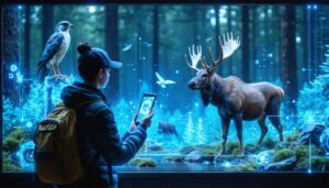
Ever wondered where that majestic moose you spotted last summer has wandered? Now you can follow the journeys of Ontario’s wildlife right from your computer or smartphone! Several Ontario Parks have embraced interactive mapping technology that lets visitors engage with real-time wildlife tracking data.
These user-friendly digital maps show the movement patterns of tagged animals across different seasons and territories. You can click on individual animals to learn their stories, see where they’ve traveled, and understand their habitat preferences. It’s like having a wildlife documentary at your fingertips!
One of the coolest features is the time-lapse function, which lets you watch how animals move throughout the year. You might discover that the bear you saw in Algonquin follows the same berry-picking route every summer, or that wolves have favorite winter hunting grounds.
For the tech-savvy nature enthusiast, many parks offer mobile apps that notify you when tracked animals are in your area. While this doesn’t guarantee a sighting, it helps you understand which trails might offer the best wildlife viewing opportunities.
Parents and teachers love using these interactive maps for educational purposes. Children can become “virtual wildlife scientists,” following animal movements and learning about habitat conservation. Some parks even offer classroom programs where students can adopt and track specific animals throughout the school year.
Remember to check the park’s website before your visit to access these fascinating tracking tools and enhance your wildlife watching experience!
Citizen Science Opportunities
Ever dreamed of being a wildlife researcher? Now you can participate in wildlife research right here in Ontario’s parks! Several exciting citizen science programs let visitors contribute to real scientific studies while enjoying their outdoor adventures.
The popular “Track & Trace” program invites park visitors to use a simple smartphone app to record wildlife sightings. When you spot an animal wearing a GPS collar or tag, you can log its location, take photos, and add behavioral observations. This valuable data helps scientists monitor animal movements and habitat use across the province.
For tech-savvy nature enthusiasts, the “Digital Wildlife Watch” program provides access to live trail camera feeds. From the comfort of your home, you can help identify and count animals captured on camera, contributing to long-term population studies.
During summer months, join guided tracking workshops where experts teach you to use professional GPS equipment and wildlife monitoring techniques. These hands-on experiences are perfect for families and aspiring naturalists.
To get started, visit your local park’s information center or download the Ontario Parks Wildlife Tracking app. Remember to follow all wildlife viewing guidelines and maintain safe distances from animals. Your observations could help shape future conservation efforts and deepen our understanding of Ontario’s incredible wildlife!
The marriage of AI and GPS tracking technology has revolutionized wildlife conservation in ways we could only dream of a decade ago. Today, researchers in Ontario’s parks and protected areas can monitor multiple species simultaneously, predict migration patterns with remarkable accuracy, and respond swiftly to wildlife emergencies – all while minimizing human interference in natural habitats.
Looking ahead, the possibilities are truly exciting. Machine learning algorithms are becoming increasingly sophisticated, potentially allowing us to decode animal behaviors and social interactions we never knew existed. Imagine being able to predict and prevent human-wildlife conflicts before they occur, or understanding how climate change affects migration patterns in real-time.
For visitors to Ontario’s parks, this technology means more meaningful wildlife encounters while maintaining a respectful distance. Through smartphone apps and interactive displays, we can now share real-time wildlife data with park visitors, creating more informed and engaged nature enthusiasts.
The future might bring even more innovative applications – from AI-powered wildlife corridors that guide animals safely through human-populated areas to smart conservation strategies that adapt to changing environmental conditions. As we continue to refine these tools, one thing remains clear: the combination of AI and GPS tracking isn’t just changing how we study wildlife – it’s transforming how we protect and coexist with the natural world around us.
Remember, this technology serves as a reminder that we can embrace innovation while staying true to our commitment to responsible and sustainable wildlife conservation.


+ There are no comments
Add yours